Category Archives: flood

Jan 2015 Flood Fair report

Flood Mitigation
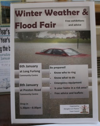
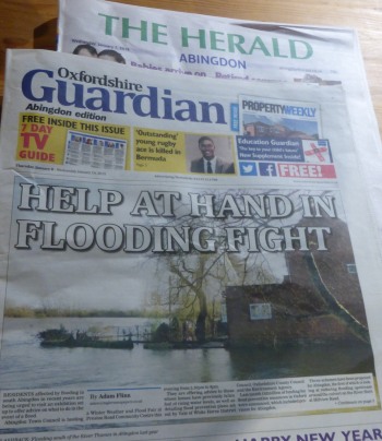
A flood and bad weather fair was put on by the Town Council at both Long Furlong  and Preston Road Community Centre.
Flood Mitigation
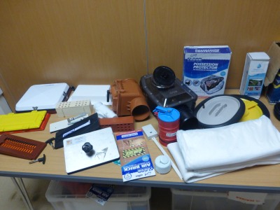
There was an array of ingenious gadgets designed to protect homes and possessions from floods.

There was the chance to pick up leaflets about what to do in the event of a flood, or other types of bad weather.
Flood Mitigation
The Environment Agency were also there to explain more about the three flood mitigation schemes being looked at for Abingdon.

Central government is now putting more money in to flood prevention, but expects more money from local partners in return.

Feasibility studies have already been done on the two simpler Abingdon schemes: to reduce flooding from the River Stert, and the River Ock at St Helens Mill. They could get the go ahead for design in Spring 2015.

During 2015 data would also be gathered to model the River Thames (Sandford to south of Mapledurham) and the River Ock Storage Area.

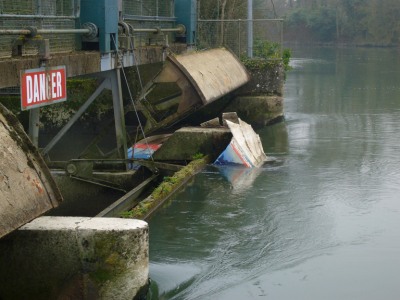
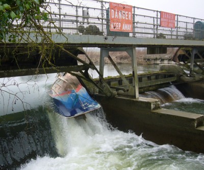
A River Ock flood storage area is the long term flood prevention proposed for Abingdon. It would hold back water outside Abingdon and release it more slowly.

Modelling would first show whether a flood storage area on the River Ock is viable. If viable then a feasibility study could begin in 2016.

The River Ock scheme will be looked at separately from the Oxford scheme, and for either scheme to go ahead they must demonstrate they will not make flooding worse downstream.

Winter Weather and Flood Fair, and news of floods 100 years ago

Winter Weather and Flood Fair
Organised  by Abingdon-on-Thames Town Council, the Winter Weather Exhibitions will give you information from experts about protecting your home this winter whether it brings flooding, snow or severe cold.

There are two such exhibitions: 6th January at Long Furlong Community Centre and 8th January 2015 at Preston Road Community Centre. Both run from 5.30pm to 8.00pm.
Winter Weather and Flood Fair
In town this morning there was also a reminder that the Town Council will recycle your Christmas Tree next Saturday on the Market Place.

The library was open and a good place to get dry, on what was a very wet morning.

I read in the Herald from 100 years ago, that there had been 6 inches of rain in December 1914 and there were floods at the start of January 1915. The removal of the canal bridge near the Drayton Road and inadequate drainage led to Tithe Farmhouse being badly flooded. The overflow of water from the River Ock, where it meets the Thames, meant the lawns of the Long Alley Almshouses were under water, and water had been forced up through the floor of the Anchor Inn. But Thames Conservancy were praised for managing the floods much better than 1894, twenty years before.
Winter Weather and Flood Fair
The Abingdon Walks website has postcards of The Great Abingdon Flood of 1894.

Reducing the Risk of Flooding

The Abingdon Herald features three Abingdon Flood Prevention schemes which have a better chance of going ahead now that central government has promised an extra £2.3 billion towards improving flood defenses.

There is some information about these projects from the Environment Agency at https://www.gov.uk/government/publications/programme-of-flood-and-coastal-erosion-risk-management-schemes .
Risk of Flooding
The most significant project would be the River Ock Flood Storage Area. That must mean holding water the other side of the A34 and releasing it more slowly. The project still needs a detailed business case, and funding agreement with partners. It could reduce the risk of flooding for 240 houses at a cost of £3.42m. Earliest start of construction would be 2016 to 2018. (Pictures from Ock Street, Drayton Road and near Caldecott Road in July 2007)

Alleviation for flooding of 2 properties by the River Stert, in Abingdon, could go ahead much sooner at a cost of £140K. The third Abingdon project would be a wall by St Helen’s Mill to protect 10 households from the River Ock – costing £0.57m.

The £42 million for the Oxford Western Conveyance is more complex, and has an earliest start of construction from 2018 to 2021.

Could this be the boat once marooned near Abingdon Lock?

This came from Stephen a couple of days ago. He says …
Marooned Boat
“I think this is the boat that used to be marooned on land between the Abingdon Bridge and Abingdon Lock. Swept downriver by the floods to the first weir (from Abingdon direction) at Sutton Courtenay, it lies smashed and wedged.”
Marooned Boat
“Even if I’m wrong I’m sure somebody can identify the boat.”

The boat in question was last seen on this blog on 12 January 2014 caught in the safety fence before Culham weir.