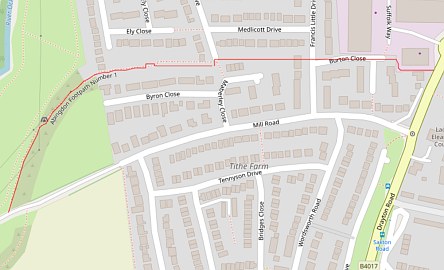
The footpath starts off near Allparts on the Ashville Trading Estate. The red line on the map, taken from https://footpathmap.co.uk, shows that a lot of its length is through houses.
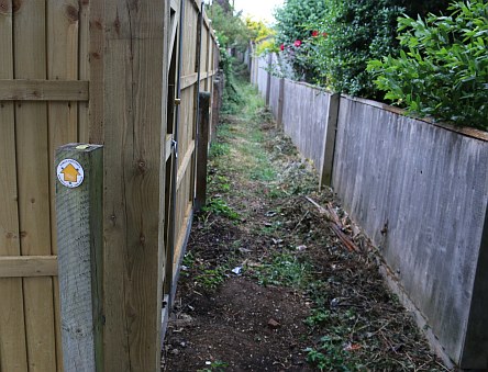
After the electricity substation on Byron Close, the footpath heads between the back garden fences of Byron Close and Ely Close.
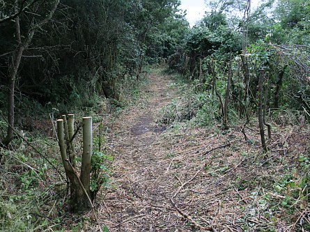
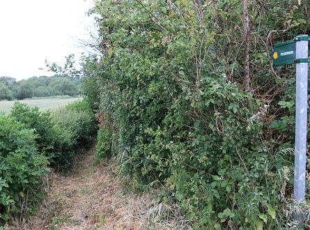
It then opens up a little as the path skirts fields. I have seen it overgrown on some occasions but this year it looks well cut back and walkable in all but one place.
I was sent an email at the start of the lockdown saying that the path had been blocked by a fence. I walked the path for the first time this evening. It is a little dangerous to clamber over one obstacle.
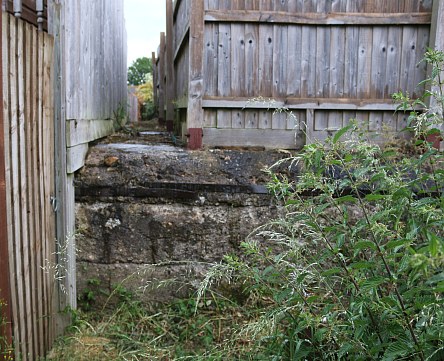
There used to be a dogleg route round the foundation of a WWII shelter. The path has been blocked at this point before and opened up again at the insistence of Oxfordshire County Council. The email is asking for pressure to be put on Oxfordshire County Council so that it is opened again.
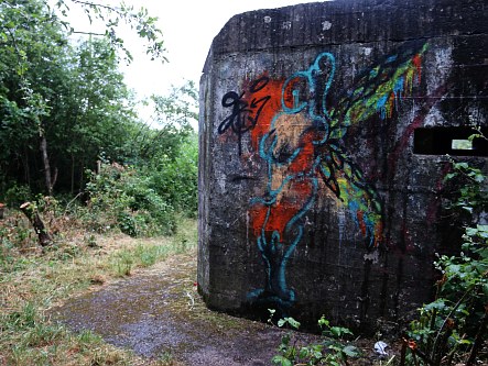
The footpath appears to follow closely the towpath of the old Wilts and Berks Canal and passes another WWII Pillbox.
At the far end is Mill Road.
The pillboxes are part of the GHQ stop line ‘red’ built from Abingdon to Pangbourne to ready us for invasion in WWII… They are part of an interesting history of our area (the dragons teeth along the Ock towards Tesco are part of the same defence).
Great that the Abingdon Blog helps to keep open footpaths. Keep on with the emails.
The Ramblers have a small group of path clearing volunteers who have cut these paths back.
An un-appealing walk along the old canal property – good
that people are trying to preserve and improve it.
It ends at Mill Road, which was known as Buggs Mill Lane
when I was a lad. I wonder how & when it was changed?
A similar question on the dropping of the ‘aitch’ (h)
from St. Nicholas; ‘who dunnit” and why?
walked this footpath Thursday a good job done clearing path there was a gate in fence to the left of the concrete and we could go round to return to foot path again.
Hope they can clear footpath 8 in Sunningwell through the old Quarry its a nice walk of interest
anybody know if bridleway 17 to Marcham from Drayton is open yet it should have been by January 2020 its a nice walk
Members of the Wilts & Berks Canal Trust have (intermittently) kept this path open after a blitz with the Ramblers Footpath Volunteers and Oxfordshire County Council. This has been repeated more recently but due to the Wilts and Berks people (me and a friend who are now 76 and 83) not now having the energy to do so it falls to other to carry the tradition on.
I produced a free walking leaflet a few years ago and when I am un-shielded I’ll get supplies back into local outlets. The dog-leg was at the insistence of OCC when there was a garden encroachment and it is interesting that a further attempt was made to block the path.
A friend of mine reckons that the blocking of that footpath 8 in Sunningwell is illegal.
your friend is right councils have a statutory duty to protect the rights of the public to use and enjoy highways and footpaths this includes a duty to prevent the obstruction or stopping up of such highways. I have emailed Oxfordshire county council but have had no reply
It looks a bit narrow for social distancing.
March to Drayton bridge still down been like that for a few year’s
Marcham Mill bridge must have been closed for over 8 years now. Is it ever going to be repaired !
OCC just file a standard route closed notice annually with a
Department for Transport stamp of approval.
Fixmystreet has this recent report:
No access from Steventon to Marcham on footpath, via this bridge
Reported in the Bridges category anonymously at 16:29, Wednesday 3 June 2020
Sent to Oxfordshire County Council less than a minute later. Council ref: 2141050.
No access from Steventon to Marcham on footpath, via this bridge. Looks like the bridge is closed off. Can’t get to marcham by foot.
Both Google maps and Roadworks.org used to flag the route as closed, but unfortunately that is no longer the case !
Not a well used footpath but a footpath none the less.Thank you, for highlighting this. Probably blocked by a houseowner trying to increase the size of their garden.