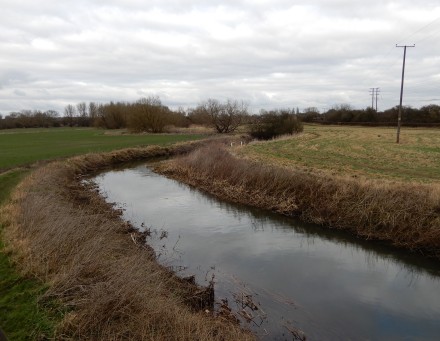
Back in 1940, after the fall of France, the UK was at risk of a German invasion. The River Ock seems to have been consolidated as a defense line to stop the ‘Blitzkrieg’. There is a pillbox one side of the river, over by the old path of the canal.
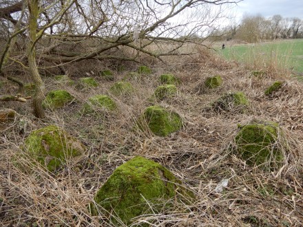
On the other side are a set of concrete dragons teeth – positioned to stop Hitler’s tanks if they try to dodge the River and the other water-filled channels. At this time of year, the vegetation has died back showing the green dragons teeth.
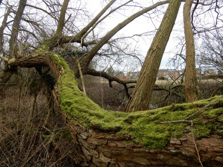
Behind the dragons teeth there is an area where willows lay. They too are covered in green at this time of year.
About 18 months ago several of these teeth vanished, possibly stolen. A great pity after having been there for over three-quarters of a century,
There’s a few interesting extra bits to be read here that mention Abingdon http://archaeologydataservice.ac.uk/catalogue//adsdata/arch-455-1/dissemination/pdf/Text_Reports/DA59_TEXT_-_FRILFORD_-_FYFIELD.pdf
What would be the value of old lumps of concrete? Hard core?
Badger, thanks for this…I have been interested in the GHQ Stop lines for a while – since moving to the area and seeing all the pillboxes, and dragons teeth and tank defences locally… Seeing how things all tie up – stop lines blue, red and green…and how close we were to a very different history as the country hunkered down and prepared itself for invasion…
It’s a rich history…
DavidofLuton – I guess to a collector of WW2 memorabilia they’d have greater value.
Daniel – Excuse the pun but there’s a lot more on the web if you dig down. There used to be yet more interesting wartime stuff around here but some of it has been erased such as the shadow factory in the woods at Tubney where Oxford Instruments factory is now. There used also to be a Pillbox visible on the right heading towards Marcham directly after the right turn that is now called Faringdon Road, I’m not sure if it has been removed or just isn’t visible as it’s had a property built next to it and trees planted around the perimeter of the land.
Something else worth watching is this https://youtu.be/ie3SrjLlcUY
The airfield mentioned is Mount Farm which is behind what is now Berinsfield, a little bit of the runway still remains and can be seen on Google Earth or if passing without trespassing as it’s an entrance.
Thanks Badger – what I’m really after is a detailed route of, initially, Stop Line red, if you ever come across such a thing…
Daniel – Here’s a bit more http://archaeologydataservice.ac.uk/catalogue//adsdata/arch-455-1/dissemination/pdf/Text_Reports/DA07_TEXT_-_SULHAM_VALLEY.pdf
I bet what you are after is in a book somewhere, probably one listed at the bottom of the linked document. I also found something written by someone who has plotted it all on Google Earth but it has no link to the map here :- https://www.google.co.uk/amp/s/chriskolonko.wordpress.com/2015/12/01/mapping-ghq-lines-in-google-earth/amp/
Daniel – if you ask on the AAAHS Google group the local historians will almost certainly know the answer – between them they seem to know about every stone in the area – and everyone who has ever lived here! I am constantly amazed, If you like I could post the question for you, but I would have to use your exact wording as the subject means nothing to me!
Fascinating! I’m going to get my daily step count in shortly with a brisk walk over there.
So many WW2 airfields around the area with bits still visible. Amazing how the country mobilised itself at short notice to face the foe. I hope we would still find that spirit today, if needed.
Daniel if you are interested in Second World War defences take a look at the pillbox study group, lots of information about the stop lines
http://www.pillbox-study-group.org.uk/
By the way, for those who are interested in this thread, at around the end of March there is going to be some sort of event at the Abingdon lock, with re-enactors commemorating the work carried out by the Upper Thames Patrol – a branch of the Home Guard I think – during WW2. Watch out for publicity nearer the time.
You may find the following of interest. The Wilts & Berks Canal Trust produce a leaflet, on-line version here, which describes the historic route of the canal and mentions the canal’s role in being part of the GHQ Red Line.
Hard copies of the leaflet are often available in the Abingdon Museum. Note that the house sign ‘The Poplars’ referred to on the Drayton Road is no longer there but the footpath sign is. The footpath from Drayton Road to Mill Lane may be blocked due to fences being blown down a few weeks ago.
Guided walks are usually organised in the Spring and Open Doors weekend in September.
https://www.wbct.org.uk/the-canal/the-towpath/walks/publication/abingdon-walk/16#page/1?fullscreen=1
There is more information on the website (a small correction – ‘Denham College’ should be Denman College):
https://hubpages.com/travel/ghq-line
Daniel- take a look at the pill box study group web site, lots of information about the stop lines on there
Thank you very much for your suggestions everyone….