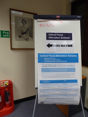
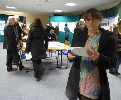
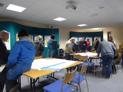
In Abbey House, Abingdon, this afternoon and evening there was a consultation event about the Oxford Flood Alleviation Scheme. There was a good turn out. People were queuing outside when they opened, and about 200 people attended.
Currently they are asking people what is the preferred route and type of channel from the Botley Road to Sandford Lock. The route is divided into sections. Section 1, near the Botley Road, has only one feasible option. Section 2 has four options etc. So we are being asked what is the preferred route in each of the places.
They are also consulting about how best to deal with the material dug out while creating the channel, and how to minimise disruption during construction. These seem to be questions more of interest for people near the route in Oxford.
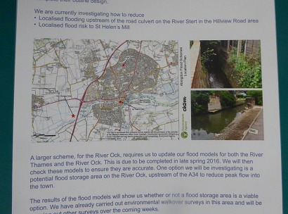
There was a board about flood alleviation options for Abingdon with smaller projects for the River Stert and the area near St Helen’Mill, and a possible larger project for holding back flood water from the Ock the other side of the A34. But that needs modelling, with the latest rainfall predictions which may need to be set 35% higher.
The recommended route of the channel should be decided by summer 2016, and the detailed design completed in 2017. They will then hold a consultation before submitting a planning application. Everybody I asked from the EA (Environment Agency) said that the project should not make things worse for Abingdon. They need to demonstrate that before getting the go ahead.
The consultation is at https://consult.environment-agency.gov.uk/portal/area/se/flood/oxford/scheme?pointId=3765916.
This scheme is clearly misguided. Any alleviation of flooding upstream of Abingdon by creating additional water channels will only create a situation where the confluence of the waterways downstream will cause flooding in Abingdon to be exacerbated. A practical example of this is the Jubilee River in Windsor which was constructed at great cost to alleviate flooding in Windsor, only to have the downstream locations such as Datchet and Wrasbury severely flooded when it was completed. Water has to go somewhere. Over 100 million pounds to minimise the flooding risk in Oxford for 1000 homes is £100,000 per home! Time to get the dredges out and do it properly. The Thames is an alluvial river and sediment continues to be built up along its length reducing the ability to carry water over time. Normally rivers such as this silt up and change course as the river becomes to shallow. The Thames is a managed river and a proper maintenance plan is required. In most areas along the river, the depth is little over 1 metre now including the centre channel.
Probably explains why I couldn’t find anything about it in the morning when I called in……
Just thought I would post some of the commentary I heard.
1. The Oxford and Abingdon schemes would not take full account of impacts they might cause to the remainder of the downstream River Thames and its tributaries. The EA agreed that holistic planning for flood risk management down the River Thames was preferable, but it was not practicable at this time!
2. The various options for flood alleviation around Oxford do not have any direct impact on Abingdon. The key aspect underpinning the Oxford options was that there would be some extension of the flood plain to the west of Oxford, thereby holding back some of the flood water and, in part, managing the surge risk downstream.
3. The previous consideration for the Oxford scheme that it would not produce an increase in the flooding levels at Abingdon above those experienced in 2013 was not directly confirmed. However the EA latest document clearly raises the issue of a potential increase in the flood risk downstream at Abingdon. It would appear that should this be the case when the preferred options are modelled, there may then be “a political solution” rather than any mitigation of the risk.
4. The EA remain of the opinion that dredging of the Thames at Abingdon would have no significant impact on the flood risks.
5. The Abingdon scheme is seeking to address the local impacts around the River Ock and producing more “flood water storage” to the west of Abingdon; two smaller tasks will be to relieve flooding of the River Stert at Hillview Road and the Ock at St Helen’s Mill.
El Padrimo, where did you get this info?
The Oxford scheme is predominantly an engineering solution to move the water past Oxford as quickly as possible. This localization concerns me greatly. The only way the EA’s strategy will work fairly for all, would be to do likewise over the whole length of the Thames starting at London and, in order, work back up to Oxford.
The lack of consideration of better using natural features (less inhabited floodplains) further upstream within the catchment area, as well as denial that dredging (not just the channels, but weir pools and streams) further underlines that whichever experts or consultants employed by the EA have little proper understanding of earth science. Nor do they appear to have an understanding of the basics of waterway management which many lock keepers have but are unable to voice.
Ultimately this looks like a numbers game, based on the number and political value of the submerged, come the next rain event.
just curious why you will not post my comment?????
Sorry John. Busy week and I did not notice it.
The information was gleaned in consultation with the EA representative attending the event!
Make planting trees a priority to reduce flooding by improving soil and drainage.
See link here
http://www.thetimes.co.uk/tto/environment/article4673574.ece
Sign petition here
https://petition.parliament.uk/petitions/117136