Monthly Archives: January 2013

Champion House Knocked down for 24 Sheltered Apartments

Champion House
Champion House, the large Edwardian House next door to John Mason School, on Wootton Road, has been demolished.
Champion House
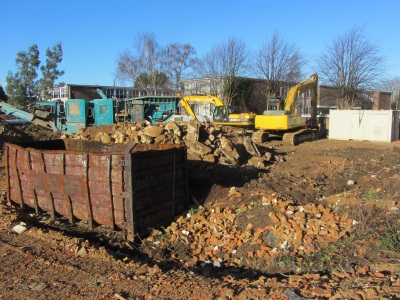
An archaelogical survey says the house was built around 1914 on the site of an orchard that had once been a quarry. More recently the building has been used as offices by Oxfordshire County Council Care Services.

The plan is to turn the area into 24 sheltered apartments with communal facilities including parking.

A previous plan for Champion House was rejected and rejected again on appeal in 2011, but having modified the plans to make more space at the front, and reduce the size of the building, plans were approved in 2012. The town council strongly objected to the original plans, worried by a narrow entrance for traffic near a school, but had “No Strong Views” in 2012.

New Years Boundary Walk 2006 & 2013 – compared

two pictures compared
Martin Smith led the boundary walk in 2006 (when I first started doing this blog) and was still there leading the walk in 2013. On both occasions he was accompanied by a town crier who rang the bell and announced to anybody in earshot that we were walking the 1556 bounds of Abingdon. In 2006 we all went into a private garden to see a boundary stone and were given mince pies – something I’ve not experienced since.
two pictures compared
This year we could not follow the normal route along the Ock Valley Walk, which is still underwater, and so went down Caldecott Road instead. At one point we saw where the canal bridge would have been.
two pictures compared
We also made a small diversion at Box Hill Walk to view where Fitzharris House once stood, and saw the Motte.
two pictures compared
The other change from 2006 was that we could now cross the new bridge over what was the Abbey Mill Stream.