Saxton Road


Saxton Road was built from the Drayton Road end to the River Thames. It was built to rehouse people from the Ock Street area of Abingdon during a 1930s slum-clearance. The work on the new houses was not very far advanced when, in 1934, the remains of a Saxon cemetary was discovered – around about the grey shaded area of the plan above.

The road however is not Saxon Road, but Saxton Road, and is named after Sir Charles Saxton who lived for some time at Caldecott House.

Saxton Road grew into a long straight terrace of Council Housing, with side alleys.

It changed recently when it was designated a home-zone. There had been too many children hit by cars, and so about two thirds of the road was redesigned, and lots of central government money spent to beautify it and slow down the cars. Now it no longer looks like one long road.

The one big complaint after the redesign was the white powdery substance used to coat the pavements. For months afterwards it was getting trodden into the houses.

There are pavement tiles designed by local residents. The mound in the foreground is used by BMXers – prehaps not its intended use. But its 20 MPH, or should be safer…

It is the road in Abingdon where you could set a TV soap opera, and not need to bring in new characters every few weeks to make it interesting.

Bury Street Shopping Centre


The precinct runs from the Market Place to an area called the Charter. The precinct was built in 1970, replacing demolished building such as the old fire station, the Corn Exchange, and Bury Street School.

Whereas many other shopping precincts have had a revamp, the Bury Street shopping centre maintains its original functional design.

The precinct belongs to a group called Threadneedle Properties, and being an investment company, they will need a fair return on any investment. There have been discussions between Threadneedle and the District Council, but no definite plans have emerged yet.

By the way, this map is a couple of months out of date. Clays Butchers has closed down. I’ll remember them for the cold storage unit outside the shop full of cellophane wrapped meat. Woolworths and Superdrug are chopped off the map, otherwise it would have been too big for this blog.

Jessops and Klick


Ivor Fields was once the main Camera shop in Abingdon, and then along came the modern looking ‘That Camera Place’. Both have closed down. I noticed for the first time this morning that ‘That Camera Place’ was gone and in its place on the Market Place, a new Jessops Shop is being kitted out.

So now we have Jessops and Klick

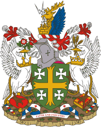
The Abingdon Coat of Arms


With the help of a brochure called Abingdon on Thames published and Copyrighted by the Vale District Council in May 2004, I shall try to explain the Abingdon Coat of Arms.

* The green shield and four small crosses and knight’s helmet come from the arms of the Fraternity of the Holy Cross.
* The large gold cross comes from the arms of Abingdon Abbey.
* A crown above represents local government
* A stags head represents Berkshire (Abingdon’s County until 1974)
* Swans represent the River Thames
* The left swan holds a Tudor rose for Mary who granted Abingdon’s first Royal Charter (1556). Its saxon crown represents the town’s saxon ancestry and it stands on a woolpack to show the long sheep farming and wool trading tradition.
* The right swan holds barley for the tradition of malting and brewing. It stands on a book for Abingdon’s leather (Pavlova) book binding and printing industry. The rope is for rope making, and its crown comes from the time of Edward the confessor and Abingdon Abbey.
* The blue wings represent the Abingdon RAF base (that was, and is now Dalton army barracks)
* The lightening for the nearby atomic energy research centre.

FAITH AND INDUSTRY (the motto): The word Faith is for the Abbey and the Church in Abingdon, and Industry is for all these aforementioned industires and more modern ones like cars (MG) and virus protection (Sophos).