
The Water Level of the River Thames in Abingdon stabilised on the O of Bristol at the Iron Bridge. It was above the O during the last high water in January 2014.
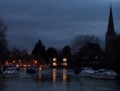
Rob sent me a picture “Looking towards St Helen’s from the Abingdon-Dorchester road“.
The Environment Agency (EA) has been telling us since the “2007 flood” that dredging rivers is not the most cost effective way to prevent flooding. Their resources are limited.

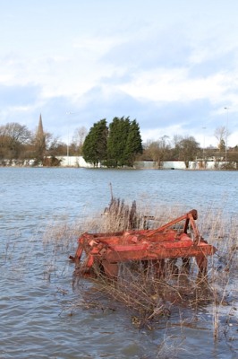
Spike sent this picture of St Helen’s Mill and the River Ock. He says “this flood barrier has achieved very little.”

The blue flood gate is out again at 60 East St Helens Street to keep out the Thames flood water.
The River Thames causes some problems in Abingdon, but our forebears were sensible – building on just one side of the River Thames.

Malcolm send me a picture of where the Ock Bridge goes under the Drayton Road – on Sunday. Here in Abingdon, it seems to be the much smaller River Ock, primarily, and the River Stert that are the main threat to properties. Malcolm says on the Safag website that the whole catchment area of the River Ock needs managing.
Has to be a more substantial barrier than that to hold back the flooding. Along the Botley Road they are backing up with pumps. -Bullstake Close- (This time pumping back onto the floodplain and not into Botley Road). Fire Brigade backed them up with barricades made of fire hoses/sandbags.
Thanks for these photos – I love it that in Abingdon we measure the flood water by the BRISTOL scale. Thoughts for those with property and livelihoods at risk.
I like using the BRISTOL scale too! I hope that Abingdon homeowners are safe and dry.
It was well below the O at 10am and the Thames was flowing at an amazing speed.
thanks for the update….. I work in health care and we use the Bristol scale for a totally different thing…..
Just checked the Bristol scale …. the Abingdon version seems a bit more pleasant!
Eastern America is bracing for a major snow and ice event so you may see something more early next week if the weather patterns come your way. Hate to see you have so much flooding
Malcolm is quite right. We need to look at long term management in the catchment areas to slow down the flow of water into the rivers in times of heavy rainfall, using natural means as far as possible.
Also checked the Bristol Scale. Not what I expected it to be!
The Bristol Scale is quite appropriate: It measures what guzunder.
In the Navy, we had a totally sexist version of the Bristol Scale !
Neil, there are several examples of “up stream” river management that work well by restricting the flow much further upstream onto established flood plains, i.e where the Ock runs through marcham common (a mile along the marcham rd for the newcomers) the EA could instal a system of flow control tubes, these are a block of tubes that only allow a pre determined amount of water through, the excess which then backs up overflows onto the flood plain, so the arable land around the Ock floods, but the built up areas do not?
..also the West End Allotments?? In the short run some of these palliatives may be OK, but longer term we need a different approach to Basin management; measures that will improve infiltration and interception up stream; also climate change must be taken seriously!
At least we seem to have seen off the disastrous Airport and Reservoir schemes!
Yes John E, but we must not forget that all these areas, Ock St, Marcham Rd, Tithe farm etc were all well known Ock flood areas, there are well documented reports of flooding here going back 100’s of years, in fact if you look on the face book link here there are photo’s of Ock St floods 100 years ago, I remember the Thames flooding past St Helens church into west St Helen’s St. Pint being is its all to easy to blame it on climate change and poor management, but never the fact that developers have been allowed to ignore history?
I agree; you will always get floods, usually on flood plains. This one is probably exceptional, but it doesn’t alter the fact that floods are more common now (the Thames Conservancy in 1967 assured me it would never happen again!), and that the range of factors I mentioned remain important if floods are to be mitigated.
The A34 embankment acts as a barrier to hold back floodwater and mitigates flooding downstream on the Ock floodplain. Before this road was constructed in the 70s, Abingdon would have been more prone to flooding from the Ock. Despite this, record breaking levels of rainfall in July 2007 and this year have been disasterous for properties on the floodplain.
The Drayton Rd Bridge classed as an Ancient Monument, similarly acts as a barrier, as Malcolm’s picture demonstrates, subjecting the Ladygrove Estate to greater risk but protecting properties downstream.
The removal of the footbridge at St Helen’s Warf by the EA, after the 2007 floods has lessened risk to the Meadowside estate, but of course it increases the rate of discharge into the Thames, increasing risks downstream.
The Jubilee River constructed in the 90s protects Maidenhead, Eaton and Widsor, but dumps water downstream on Staines, Egham and Chertsey with disasterous effect.
Dredging is ineffective as it acts to conduct water downstream, is prone to rapid silting-up and undermines bridges. In this new era of torrential rainfall, the best mitigation option is probably to use vegetation and trees in catchment areas to slow the flow into river channels. Ploughed arable fields and well maintained ditches act to conduct water and silt more rapidly into the river channels, exacerbating flooding. Of course farmers don’t want flooding on their land.
There are no measures that will not have adverse effects elsewhere. There will have to be compromises.
A lot of flooding is due to unwise farming methods in the upper basins – especially the Thames whose catchment focuses on Oxford. Monbiot’s article in the Guardian of Tuesday points out that the widespread cultivation of maize as well as the compression of farm machinery is limiting the ability of soils to absorb water and hence so much goes to run-off hence to the……Thames!!
He says that Government policy has encouraged this!